The Earth Is Itself a Giant Magnet
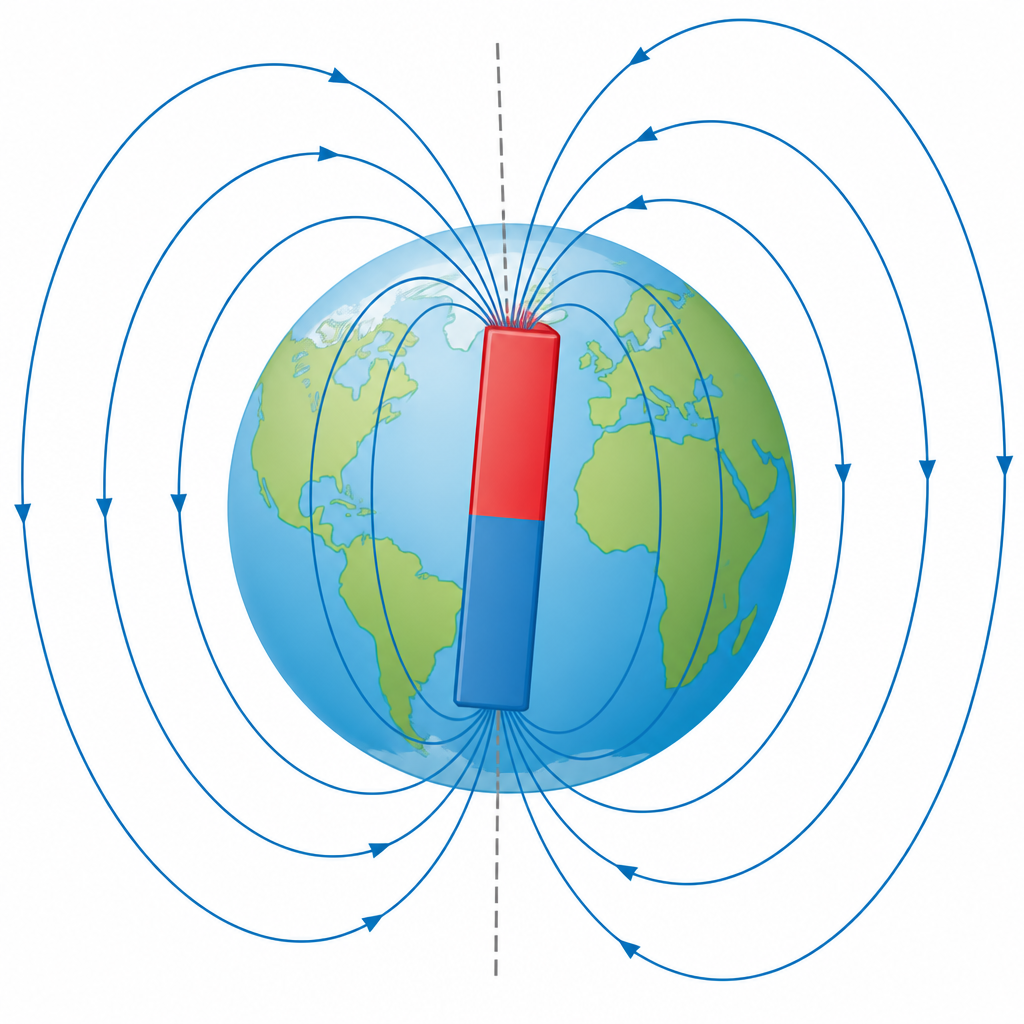
A compass needle left in the open does not stop just anywhere. It swings one way, then the other, slows down, and finally settles with one end facing north. Something must be turning it, and that something is the Earth itself. The Earth behaves like one enormous magnet, and for that reason it is called a geomagnet.
Geomagnet: the Earth is itself a huge magnet, and that magnet is called the geomagnet. Like any other magnet it has two poles, a geomagnetic north pole and a geomagnetic south pole.
These two poles do not stay in one place for ever. Deep inside the Earth, molten iron and nickel are always in motion, and that motion keeps shifting the geomagnetic poles. Over many years their positions move. The Earth's magnetism is therefore not something fixed and finished. It changes slowly all the time.
Inside the Earth: Where the Magnetism Comes From
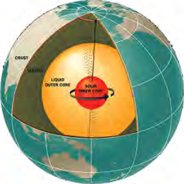
The outer shell of the Earth is called the crust, below it lies the mantle, deeper still is the liquid outer core, and right at the centre sits the solid inner core. The molten iron and nickel of the liquid outer core are always flowing. That flow produces a magnetic field all around the Earth, and this field is called the geomagnetic field. The field does not stop at the ground. It reaches far out into space.
Seen from outside, the effect is exactly as though a big bar magnet were buried inside the Earth. The axis of that imaginary magnet does not line up with the axis the Earth spins about. It is tilted a little away from it. That small difference is what produces magnetic declination, which is studied later in this topic.
Evidence That the Earth Is a Magnet
You cannot see that the Earth is a magnet. You can only see what the Earth does to other things. The four observations below are the evidence.
- If an iron bar is buried in the ground lying north to south, after some time that bar begins to show magnetic properties, because the geomagnet has acted on it.
- A bar magnet hung so that it can turn freely always comes to rest pointing north and south.
- The existence of a neutral point is the result of the combined effect of the geomagnetic field and another magnetic field.
- Natural magnets are found in the Earth only because the Earth itself is a magnet.
The first two pieces of evidence can be tested in the classroom. However many times you turn a freely hanging bar magnet, it always comes back to rest along the same line.
What the Earth's Magnetism Does for Us
The Earth's magnetism does far more than turn a compass needle. It shields the living things on the Earth, it helps us read the history of rocks, and it shows travellers the way.
- Because of the geomagnetic field, the ultraviolet rays that come from a solar storm strike the ozone layer and turn back into space, so their effect on the Earth is reduced.
- Studying the magnetic material inside igneous rock, and the way it is aligned, helps us work out the age of the rock and helps in the search for mineral ores.
- The magnetic compass was invented on the basis of the geomagnetic field, and with its help the direction of a place can be found from a ship or an aeroplane.
The Two Elements of the Earth's Magnetism
The Earth's magnetism is not the same everywhere. What a compass needle does in Kathmandu is not quite what it does at the foot of a Himalayan valley or in the middle of an ocean. Two quantities are used to put a number on that difference. The first is magnetic declination, which measures how far sideways the needle is turned. The second is magnetic dip, which measures how far the needle tilts away from the horizontal.
Magnetic Declination
To understand declination you first have to know two meridians. One is drawn by the geography of the Earth and the other by the magnetism of the Earth.
Geographical meridian: the surface that joins the north pole and the south pole of the Earth is called the geographical meridian.
Geomagnetic meridian: the surface that joins the north pole and the south pole of the geomagnet is called the geomagnetic meridian.
Magnetic declination: the angle formed at any place between the geographical meridian and the geomagnetic meridian is called the magnetic declination.
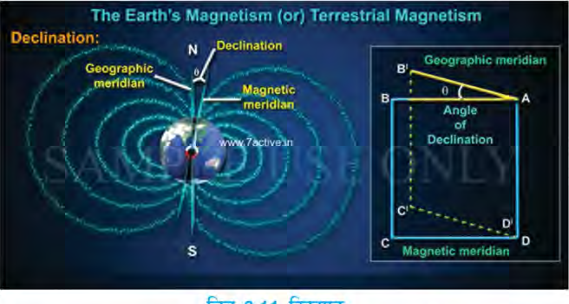
Declination is measured in degrees. Its value runs from 0° up to 90°. At the magnetic pole of the Earth the magnetic declination is 90°, and at the equator of the geomagnet its value is 0°. Near the equator the two meridians almost lie together, and as you move towards the pole the angle between them grows.
Its value is worked out with a declinometer, a declination calculator, a declination table and a magnetic compass. Today the value of declination can also be taken from an aeronautical map or from software. Declination is used mainly by aeroplanes, ships and travellers to find direction.
The north a compass needle shows and the geographic north printed on a map are not the same north. The geomagnetic pole does not sit exactly on the geographic pole, so the true geographic north is found only after the declination angle is added to, or taken away from, the direction the needle shows.
Finding Direction with a Magnetic Compass
For this you need nothing but a magnetic compass. The aim is to learn to fix direction with a magnetic compass.
- Place the magnetic compass on a level surface at the place you have chosen.
- Wait until the needle stops swinging and comes completely to rest.
- Observe the direction shown by the magnetic needle of the compass.
- Compare the direction it shows with a direction you already know at that place.
- Draw your conclusion about which direction the compass needle turns towards.
The same work can be repeated at several places using the compass or the software in a mobile phone. The record of each place can be written into a table like the one below and then presented in class.
| Place | Instrument used | Object lying towards north | Remarks |
| School ground | Compass in a mobile phone | The flag pole | Read after the needle came to rest |
| Beside the classroom window | Magnetic compass | The library building | Kept away from the iron chairs |
Magnetic Inclination or Angle of Dip
Declination measures how far the needle turns to the left or right. But a needle hung so that it can turn freely does not stay level. One end tips downwards. The quantity that measures this tipping is the magnetic inclination. Magnetic inclination is also called the magnetic dip.
Magnetic inclination: the angle that a freely suspended magnetic needle makes with the horizontal at a place is called the angle of dip.
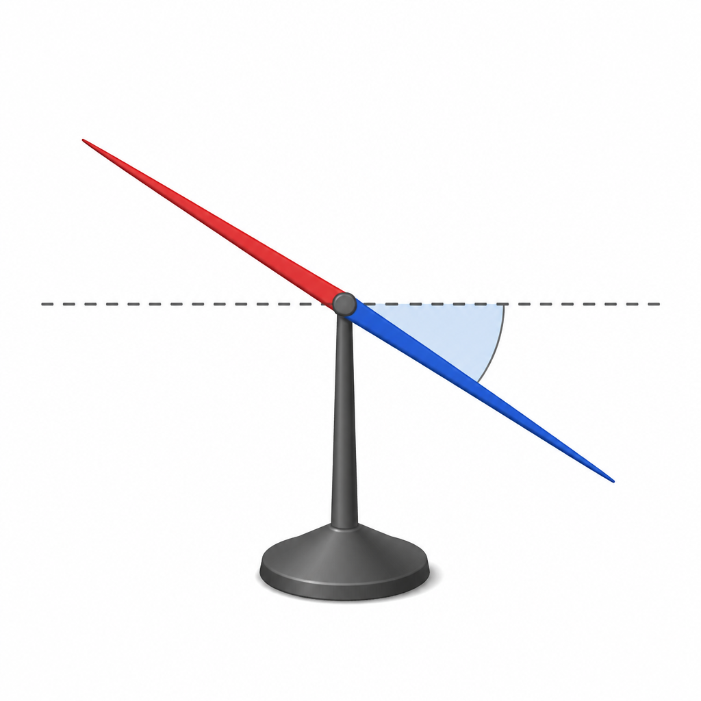
The value of the dip is different at different places on the Earth. At the geomagnetic equator the magnetic needle lies parallel to the horizontal, so the angle of dip there is 0°. At the geomagnetic pole the needle stands upright and makes an angle of 90°. As you travel from the equator towards the pole, the needle tips more and more steeply.
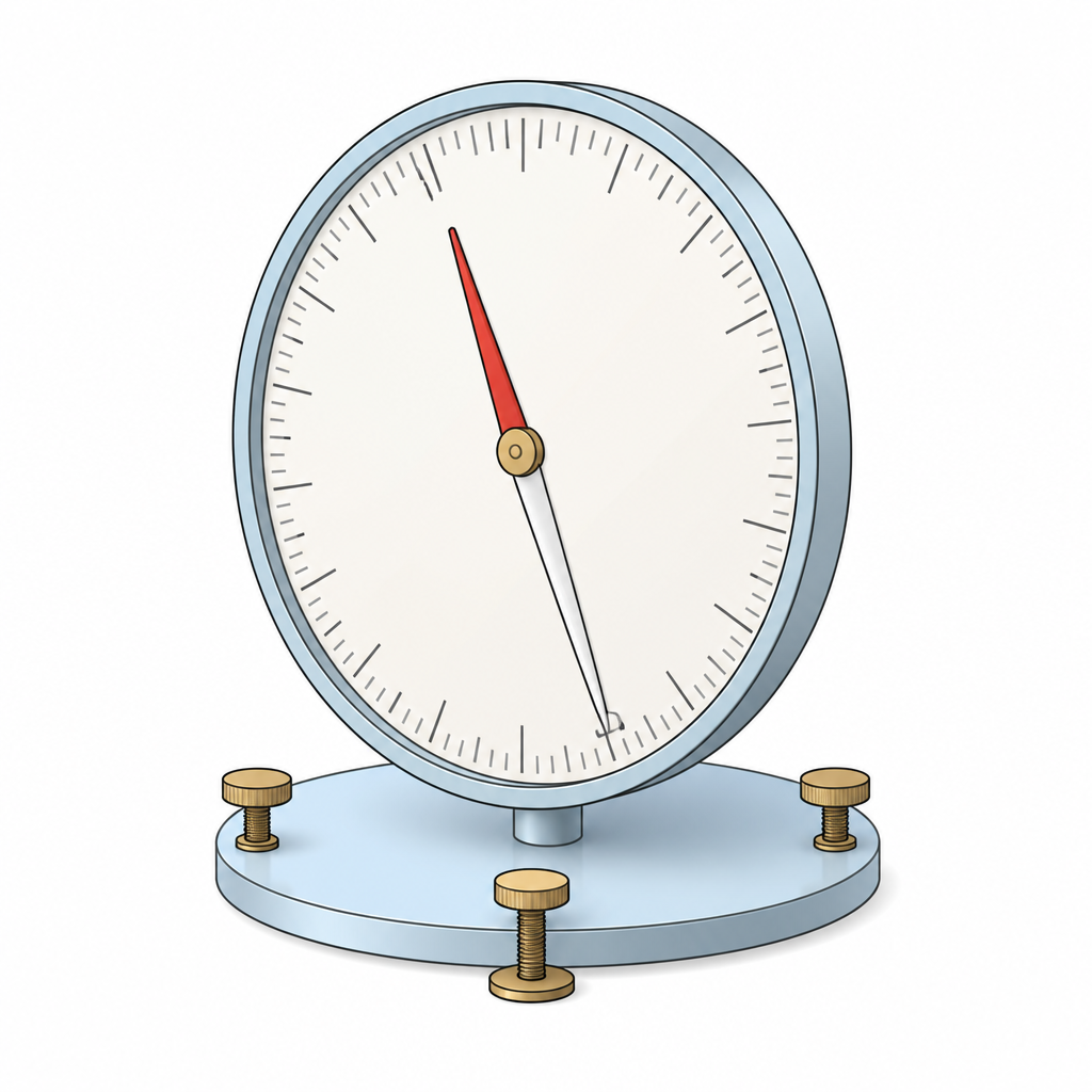
The dip is measured with a dip circle. In Kathmandu, the federal capital of Nepal, the value of the magnetic dip is 42°. The dip is used in geological and geographical mapping.
These two are easily swapped. Declination is measured in the flat plane and is the angle between two meridians. Dip is measured in the upright plane and is the angle between the needle and the horizontal. Even the instruments used for them are different.
Declination and Dip Side by Side
| Basis | Magnetic declination | Magnetic dip |
| Which angle | Between the geographical meridian and the geomagnetic meridian | Between the needle and the horizontal |
| Value at the equator | 0° | 0° |
| Value at the pole | 90° | 90° |
| Measured with | Declinometer, declination table, magnetic compass | Dip circle |
| Chiefly used for | Finding direction by aeroplanes, ships and travellers | Geological and geographical mapping |
The full lesson is waiting for you
The notes are free to read in full. A free account opens the rest of the practice, and tracks your progress and confidence score for every subject. Presentations and videos need approval from Learn Yeti.